- Scan Rate: CR-S1 offers increased point-cloud density and extended scanning range compared to its predecessor, the CR-S2. - Market Growth: Global 3D scanning market projected to reach over $19 billion by 2035. - Accuracy: CR-S1 achieves centimeter-level absolute accuracy with integrated GNSS and Topnet Live RTK corrections.
Experts would likely conclude that the CR-S1 represents a significant advancement in handheld 3D scanning technology, particularly for its integration of high-accuracy GNSS and seamless software workflows, addressing critical needs in construction and geomatics industries.
Topcon Unveils CR-S1 Scanner for Connected Workflows
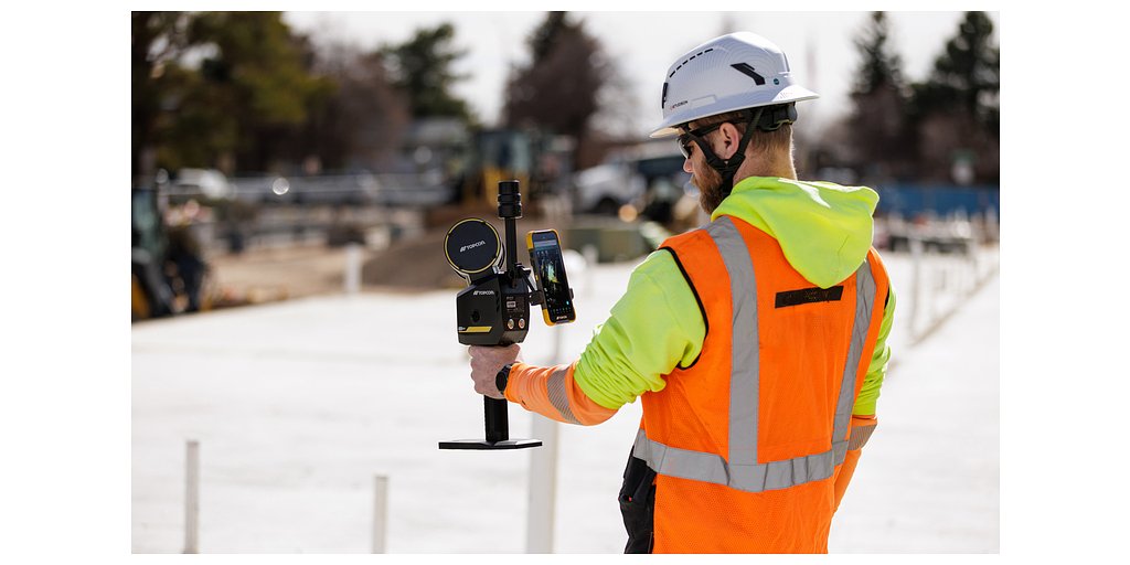
LIVERMORE, CA – February 17, 2026 – Topcon Positioning Systems today announced a significant expansion of its Capture Reality portfolio with the introduction of the CR-S1, a handheld scanning system designed to merge high-performance data capture with a seamlessly connected software workflow. The new device integrates LiDAR, panoramic cameras, visual SLAM (Simultaneous Localization and Mapping) cameras, and a GNSS antenna into a single, portable unit, aiming to set a new benchmark for efficiency and accuracy in the field.
Positioned as a higher-performance option alongside the existing CR-S2, the CR-S1 promises increased point-cloud density, an extended scanning range, and upgraded panoramic imaging. This launch signals Topcon's sharpened focus on providing versatile, powerful tools for the rapidly digitizing construction and geomatics industries, where the demand for fast, reliable, and comprehensive 3D data has never been greater.
A New Standard in Multi-Sensor Integration
The CR-S1 represents a convergence of multiple advanced technologies into one ergonomic package. By combining a high-density LiDAR sensor with visual SLAM cameras, the system can generate detailed 3D point clouds in real-time while tracking its position within a space. This allows operators to capture complex environments simply by walking through them, drastically reducing the time spent on-site compared to traditional static scanning methods.
What sets the CR-S1 apart is its integrated GNSS antenna, which can connect to Topcon's Topnet Live RTK corrections service. This feature allows the scanner to achieve centimeter-level absolute accuracy in outdoor environments, directly georeferencing the captured data in the field. This eliminates a cumbersome and time-consuming post-processing step, providing survey-grade accuracy for large-scale projects like land surveying, utility mapping, and infrastructure inspection. While its predecessor, the CR-S2, already offered robust performance with a scan rate of 200,000 points per second and a 70-meter range, the CR-S1 is engineered to surpass these metrics, delivering richer datasets over larger areas.
Navigating a Competitive Digital Landscape
Topcon's launch of the CR-S1 comes as the global 3D scanning market experiences explosive growth, with projections showing it reaching over $19 billion by 2035. This growth is fueled by the widespread adoption of digital workflows in construction and infrastructure, where 3D data is critical for improving accuracy, reducing rework, and shortening project timelines. The CR-S1 enters a competitive field populated by established solutions like the Leica BLK2GO, known for its portability and 420,000 points-per-second scan rate, and the Trimble X7, a high-speed system lauded for its in-field registration and automatic calibration features.
Against this backdrop, Topcon is positioning the CR-S1 not just on its hardware prowess but on its strategic integration of high-accuracy GNSS and its open software ecosystem. While many handheld SLAM scanners excel at rapid indoor mapping, the CR-S1’s ability to produce globally accurate coordinates on the fly gives it a distinct advantage in mixed indoor-outdoor projects and large-scale civil works. This focus on absolute accuracy directly addresses a critical pain point for surveyors and construction professionals who require data that is not just internally consistent but precisely located in the real world.
The Power of the Collage Ecosystem
Central to the CR-S1's value proposition is its integration with the Topcon Collage mass-data software ecosystem. The company emphasizes that the hardware is just one piece of a comprehensive, end-to-end workflow designed for collaboration and interoperability.
“Customers are looking for flexibility and efficient workflows, and our scanning portfolio and software are designed to support these needs through simplified processes, open integrations and mixed‑fleet compatibility,” said Ron Oberlander, head of the Topcon Geomatics Platform. “With Collage serving as the central data hub supporting inputs from multiple sensors, users can obtain accurate, detailed information for decision‑making.”
The ecosystem includes several key components. Data captured in the field can be managed via MAGNET Flow on mobile devices. Desktop processing of the SLAM data is handled by MAGNET Bridge. The core of the platform is Collage Web, a cloud-based service that allows stakeholders to visualize, explore, and share massive 3D point-cloud datasets directly in a web browser, eliminating the need for specialized software on every user's machine.
Furthermore, Topcon's commitment to an open strategy is evident in its Collage Cloud Connector. This application facilitates seamless data synchronization and integration with industry-standard third-party software, including Autodesk products and ClearEdge3D's Verity and EdgeWise platforms for construction verification and automated feature extraction. This ensures that data from the CR-S1 flows smoothly into existing BIM and digital twin workflows, reinforcing Topcon's strategy to be a central player in the connected construction landscape.
Democratizing Data Capture on the Job Site
Beyond its technical specifications, the CR-S1 is designed for accessibility and versatility. The system offers multiple mounting options, including backpack and front-pack configurations for hands-free scanning, a traditional rover-pole mount for survey-style operation, and a vehicle adapter for mobile mapping applications. This flexibility allows a single device to be deployed across a wide array of scenarios, from capturing intricate details inside a tunnel to mapping a long utility corridor.
This versatility extends the power of high-density 3D scanning to a broader range of applications, including forestry analysis, mining operations, and power line inspection. By simplifying the capture process and providing a clear path from field to finish, Topcon aims to democratize a technology that was once the domain of highly specialized experts. The CR-S1 will be showcased at Geo Week 2026 in Denver, Colorado, and will be available through the Topcon dealer network, which will provide comprehensive training and support to ensure users can maximize their investment from day one.
Topics & Related
AI & Machine Learning
Generative AI
Machine Learning
Related Company Pulse