- Price: $399, a fraction of traditional navigation solutions ($10,000–$100,000).
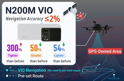
- Accuracy: 2% continuous positioning error, a 300% improvement over previous models.
- Size & Weight: 43% smaller and 54% lighter than the previous generation.
Experts would likely conclude that UNIBIRD's N200M module represents a significant advancement in drone navigation technology, offering high precision and affordability that could democratize autonomous drone operations across various industries.
UNIBIRD's $399 Module Redefines Drone Navigation Without GPS
DUBAI, UAE – March 17, 2026 – In a move set to significantly disrupt the drone industry, Dubai-based UNIBIRD has officially launched its N200M Visual Navigation Module, a high-performance system designed to give drones precise positioning capabilities in environments where GPS is unavailable. The upgraded module promises a dramatic leap in accuracy and adaptability while maintaining the game-changing $399 price point of its predecessor, democratizing advanced autonomy for a new generation of unmanned aerial vehicles.
For years, reliable drone operation has been tethered to a stable GPS signal, limiting missions inside buildings, within dense urban canyons, underground, or in areas susceptible to signal jamming and spoofing. The N200M confronts this challenge head-on, leveraging AI-based visual navigation to provide stable and reliable self-localization, effectively giving drones the ability to see and navigate on their own.
A New Standard in Performance and Accessibility
Following the successful market introduction of the N200, the world's first mass-produced Visual-Inertial Odometry (VIO) module, the new N200M delivers substantial upgrades across the board. The device is 43% smaller and, at just 128 grams, is 54% lighter than the previous generation. This significant reduction in size and weight is a critical enhancement for drone manufacturers and operators, as it reduces payload, extends flight endurance, and improves compatibility with a wider range of smaller drone frames.
Perhaps the most significant claim is a staggering 300% improvement in accuracy. UNIBIRD specifies a continuous positioning error within 2%, a metric that positions the N200M competitively against state-of-the-art visual odometry systems, which often target an accuracy of around 1% of the total distance traveled. This level of precision is a major leap for a commercially accessible module.
What truly sets the N200M apart in the market is its price. At $399, it costs a mere fraction of traditional navigation solutions. High-precision fiber-optic gyroscope (FOG) inertial systems, which offer top-tier accuracy, can command prices from $10,000 to over $100,000. By offering a robust alternative at roughly one-twentieth the cost, UNIBIRD is effectively breaking down the financial barriers that have kept sophisticated autonomous navigation out of reach for small businesses, academic researchers, and independent developers.
Conquering Complex Environments
The core value of the N200M lies in its ability to perform where other systems fail. Many commercial drone operations are aborted or deemed too risky when GPS signals are weak or obstructed. The module is engineered to thrive in these scenarios. It boasts an operational altitude of up to 200 meters (656 feet), a four-fold increase over the 46-meter limitation of many existing visual navigation systems, allowing for missions at greater heights.
Furthermore, it can maintain stable localization while traveling at speeds of up to 15 m/s (54 km/h), with a low-latency data output of 30 Hz. This capability is crucial for applications that require rapid movement, such as surveying large areas or tracking moving objects. By tightly coupling data from its onboard sensors, the N200M maintains its 2% positioning accuracy even in challenging conditions like low-texture environments (e.g., white walls or open fields), during high-speed flight, or under direct electronic warfare threats like strong electromagnetic interference and GPS spoofing.
The Technology Behind the Breakthrough
The N200M's impressive capabilities are powered by a sophisticated application of Simultaneous Localization and Mapping (SLAM). This technology allows the drone to build a 3D map of its surroundings in real-time while simultaneously tracking its own position and orientation within that map. Unlike systems that rely on pre-existing data, the N200M requires no preloaded maps, enabling true autonomous operation in completely unknown territories.
This is achieved through an advanced sensor fusion process driven by AI-based algorithms. The module seamlessly integrates data from its visual cameras, a laser-ranging sensor (LiDAR), and an Inertial Measurement Unit (IMU). The AI algorithms intelligently process this stream of information, identifying and tracking stable features in the environment to calculate movement and position. This adaptive feature-tracking is robust enough to overcome common challenges like motion blur during aggressive maneuvers, ensuring the drone always has a stable reference for its location.
Redefining Drone Integration and Applications
By solving a critical technical challenge at an accessible price, the N200M is poised to unlock a new wave of drone applications across numerous sectors. In public safety, search and rescue teams can deploy drones inside collapsed buildings or disaster areas without fear of losing navigation. For industrial inspection, drones can now safely survey the interior of large boilers, the underside of bridges, or pipelines in dense industrial plants. In defense, the module offers a resilient navigation solution for reconnaissance and surveillance missions in electronically contested airspace.
The impact also extends to logistics, where drones could autonomously navigate vast warehouses for inventory management, and to academic research, where students and scientists gain access to advanced tools for robotics and AI development. The technology's accessibility empowers small and medium-sized businesses to develop innovative drone services that were previously the domain of large corporations with deep pockets.
Lowering the barrier to adoption further is the module's ease of integration. The N200M adheres to the MAVLink standard protocol and is designed for plug-and-play compatibility with the industry's most popular open-source flight controllers, including PX4 and APM. According to UNIBIRD, integration can take just a few minutes with minimal tuning, drastically reducing development time and costs for drone manufacturers. This combination of performance, price, and accessibility positions the N200M not just as an incremental product upgrade, but as a potential catalyst for the next era of widespread drone autonomy.