Uncrewed Vessels Chart Path to Gulf's Environmental Recovery
- 1,391 square nautical miles: The area being surveyed to map deep-sea corals and marine habitats.
- 90 days: The endurance of the uncrewed vessel (MC40) operating without human intervention.
- 11,000 linear nautical miles: The distance the USVs will travel to gather high-resolution seafloor data.
Experts agree that the use of uncrewed vessels for deep-sea mapping significantly enhances safety, efficiency, and data quality, setting a new standard for marine conservation and ecological restoration efforts in the Gulf of Mexico.
Uncrewed Vessels Chart Path to Gulf's Environmental Recovery
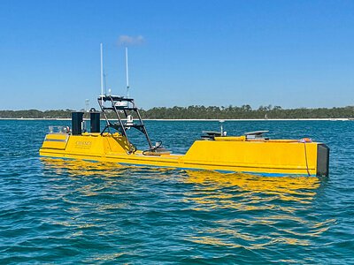
PENSACOLA, FL – May 05, 2026 – A fleet of robotic ships is currently navigating the waters off Florida's Gulf Coast on a mission that blends high-tech innovation with critical environmental restoration. Geospatial firm Woolpert, in a landmark collaboration with Chance Maritime Technologies, has launched its first fully uncrewed offshore hydrographic survey for the National Oceanic and Atmospheric Administration (NOAA). The multi-month project utilizes advanced autonomous vessels to map the deep-sea floor, gathering data essential for healing the lingering ecological wounds of the 2010 Deepwater Horizon oil spill.
The mission will cover 1,391 square nautical miles, focusing on deep-sea corals and other sensitive marine habitats. This effort marks a significant step forward in marine surveying, demonstrating how automation can enhance the safety, efficiency, and scale of ocean exploration and conservation.
The Robotic Revolution Beneath the Waves
At the heart of this operation are two uncrewed survey vessels (USVs): the new, high-endurance 40-foot Chance MC40 and its smaller counterpart, the Chance MC29. These vessels are not mere drones; they are sophisticated, long-range platforms capable of operating continuously for extended periods. The MC40, for instance, can remain at sea for over 90 days without human intervention onboard. This endurance allows for uninterrupted data collection, a feat impossible with traditional crewed ships that are bound by human endurance and shift changes.
Equipped with Woolpert's advanced multibeam sonar, the USVs will travel approximately 11,000 linear nautical miles, painting a high-resolution picture of the seafloor. In a testament to the technology's global and remote nature, Woolpert hydrographers stationed across multiple time zones are piloting the vessels and overseeing data acquisition around the clock. Data is beamed via Starlink satellite to a cloud server, where it is immediately ingested by Woolpert's Automatic Survey Production Environment (ASPEN) for processing. This seamless workflow drastically reduces the time from data collection to analysis.
The benefits of this uncrewed approach are profound. By removing crews from the offshore environment, the mission inherently eliminates risks to human life, particularly in the unpredictable and often challenging conditions of the deep ocean. This technology also offers superior data quality, as the absence of a large vessel and crew reduces engine vibrations and noise that can interfere with sensitive sonar equipment.
"Uncrewed vessels allow us to collect high-quality hydrographic data more efficiently and safely, particularly in challenging deep-ocean environments," said Woolpert Program Director Dave Neff in a statement. "This project demonstrates just how valuable USVs are in expanding our access to critical ocean data while reducing operational risk. We're proud to support NOAA's mission and to help set a new precedent for large-scale offshore marine mapping."
Healing the Wounds of Deepwater Horizon
While the technology is futuristic, the mission's purpose is rooted in addressing a past catastrophe. The 2010 Deepwater Horizon disaster, the largest oil spill in U.S. history, caused immense and lasting damage to the Gulf of Mexico's ecosystems. More than 770 square miles of deep-sea habitat were impacted, devastating the mesophotic and deep benthic communities—complex ecosystems of corals, sponges, and other invertebrates that form the foundation of the Gulf's food web.
This survey directly supports the ongoing restoration efforts managed by the Deepwater Horizon Natural Resource Damage Assessment Trustee Council. The high-resolution maps of seafloor topography and texture generated by the USVs are not just for updating nautical charts; they are a critical tool for ecologists.
"This project will fill gaps in modern seafloor mapping data in the Gulf of America," explained Chris Taylor, Ph.D., an ecologist with NOAA's National Centers for Coastal Ocean Science. "New maps of seafloor bathymetry and texture will be used by NOAA and our partners to develop new habitat maps and characterizations supporting the restoration of mesophotic and deep benthic communities in the region that were damaged during the Deepwater Horizon oil spill."
This data provides a crucial baseline, allowing scientists to identify injured sites, monitor recovery, and plan targeted restoration interventions, such as the propagation and outplanting of deep-sea corals. By precisely mapping these fragile environments, the mission provides the scientific foundation necessary for long-term ecological healing.
Navigating New Regulatory and Economic Frontiers
The Woolpert-Chance Maritime mission is not just a scientific endeavor; it's a real-world test case at the forefront of a rapidly evolving industry. The adoption of autonomous vessels is accelerating, but the regulatory frameworks governing the seas are still catching up. International bodies like the International Maritime Organization (IMO) and national agencies like the U.S. Coast Guard are actively working to create rules for Maritime Autonomous Surface Ships (MASS), addressing complex issues of safety, liability, and operational protocols. Projects like this provide invaluable data for regulators, demonstrating the capabilities and reliability of the technology in a controlled, mission-focused environment.
This collaboration is also a model for the burgeoning "blue economy." The partnership leverages the complementary strengths of two specialized firms: Woolpert's century of experience in geospatial services and hydrographic analysis, and Chance Maritime's cutting-edge expertise in USV design and operations. Their previous successful hybrid crewed/uncrewed survey for the Florida Seafloor Mapping Initiative laid the groundwork for this more ambitious, fully autonomous project.
By proving the commercial and operational viability of uncrewed surveys, this partnership is helping to define a new market for marine services. The ability to deliver high-quality data more safely, quickly, and cost-effectively opens up new opportunities for scientific research, environmental monitoring, and infrastructure management. As the survey continues its work mapping the hidden depths of the Gulf, it is also charting a course for the future of humanity's relationship with the ocean.