New AI Model Maps Urban Firestorms, Rewriting Wildfire Playbook
- $4–6 billion: Estimated insured losses from the 2023 Lahaina, Maui fire, a devastating urban conflagration.
- 12 unique WUI fuel types: Technosylva's model differentiates between urban and wildland fuels to improve fire spread predictions.
- 1,000+ homes destroyed: The 2021 Marshall Fire in Colorado demonstrated the rapid urban fire spread risk.
Experts agree that Technosylva's AI model represents a critical advancement in wildfire science, addressing long-standing gaps in predicting urban firestorm behavior and providing actionable insights for disaster mitigation.
New AI Model Maps Urban Firestorms, Rewriting Wildfire Playbook
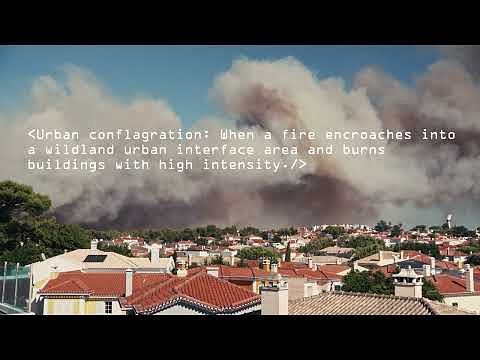
LA JOLLA, CA – April 22, 2026 – For decades, the digital tools used to predict a wildfire’s path treated cities and towns as fireproof barriers, effectively drawing a line at the edge of a community and going dark. Wildfire science firm Technosylva today announced a major technological leap designed to erase that blind spot, launching an enhanced urban conflagration model that simulates how fire spreads through the built environment.
The groundbreaking system addresses a critical, and often tragic, limitation of traditional wildfire modeling. By treating populated areas as “non-burnable,” previous models failed to provide forward visibility once flames reached the Wildland-Urban Interface (WUI)—the zone where development meets wilderness. This left fire agencies and utilities with a gap in intelligence at the most crucial moment, as seen in the catastrophic urban firestorms that have recently devastated communities like Lahaina, Hawaii, and Marshall County, Colorado.
Technosylva's new model aims to change that, providing what it calls the first-of-its-kind intelligence on how fires behave once they begin consuming homes, businesses, and infrastructure.
“Recent devastating fires have made one thing clear: populated areas face disproportionate impacts—and require greater focus to protect them,” said Bryan Spear, CEO of Technosylva, in the announcement. “Traditional wildfire models were designed for wildland fuels and fire behavior. Our approach builds on that foundation by showing how fires actually move through communities.”
The End of the 'Non-Burnable' Myth
The new technology represents a significant paradigm shift, moving away from a long-held limitation in fire science. Established and widely used wildfire models like FARSITE have been instrumental in predicting fire spread across forests and grasslands but were not designed to handle the complex physics of an urban firestorm. The fuel in a city is not just trees and brush; it’s a heterogeneous mix of wooden structures, asphalt shingles, manicured lawns, and flammable materials that create entirely different fire behavior.
Fire science experts have long noted that in WUI disasters, the homes themselves become the primary fuel source. Once a structure ignites, it can launch a cascade of embers and generate intense radiant heat, leading to structure-to-structure ignition that can rapidly outpace ground-level fire spread through vegetation. The result is a conflagration, a fast-moving, large-scale urban inferno that traditional models could not anticipate.
Technosylva's model tackles this by introducing 12 unique WUI fuel types. This allows the system to differentiate between a dense pine forest and a suburban neighborhood with wood-shingled roofs, factoring in how built infrastructure becomes a fuel source. This granular detail is critical for understanding the rate of spread, intensity, and speed of fires once they cross into populated areas.
A Response to Billion-Dollar Disasters
The urgency for such a tool is underscored by a grim tally of recent disasters. The 2023 fire in Lahaina, Maui, was a devastating example of an urban conflagration, claiming over 100 lives and causing an estimated $4 to $6 billion in insured losses as flames swept through the historic town. Similarly, the 2021 Marshall Fire in Colorado destroyed over 1,000 homes in a matter of hours during a winter windstorm, resulting in $2 billion in damages and proving that WUI fire risk is not limited to hot, dry summers.
These events, along with the 2016 Gatlinburg fires in Tennessee, have exposed the vulnerability of communities not built to withstand ignition from wind-driven embers. According to a 2023 article in the Proceedings of the National Academy of Sciences, “community fire destruction has become a national crisis.” With the WUI being the fastest-growing land use type in the United States, millions of homes are at increasing risk.
Technosylva’s model was trained on a comprehensive database of these WUI fires, using machine learning to analyze the environmental conditions, weather patterns, and fuel characteristics that drive urban firestorms. A key component is the new Dynamic Building Loss Factor, an AI-driven feature that assesses the vulnerability of individual structures. It leverages characteristics like building age, construction materials, and proximity to other buildings to predict which structures are most likely to be lost. This provides a level of insight far beyond simply knowing a community is threatened; it identifies why and where the highest risks lie.
From Data to Defensible Communities
The practical implications of this enhanced modeling are vast, providing actionable intelligence for utilities, emergency responders, and policymakers. For electric utilities operating in high-risk states like California, the technology offers a more sophisticated tool for managing their Wildfire Mitigation Plans (WMPs), which are mandated by regulators like the California Public Utilities Commission (CPUC).
By accurately modeling fire spread through towns, a utility can better identify which specific power lines or substations are most vulnerable, allowing for more targeted asset hardening, such as undergrounding lines or replacing wooden poles. It can also lead to more precise Public Safety Power Shutoff (PSPS) decisions, potentially reducing the footprint of outages while still mitigating ignition risk during extreme weather events.
The intelligence can also directly influence urban planning and policy. With data that quantifies the risk associated with certain building densities or older construction materials, local governments have a powerful tool to advocate for and enforce stronger building codes, such as those outlined in Chapter 7A of the California Building Code for ignition-resistant construction. It allows planners to design more fire-resilient communities from the ground up.
For insurers, the model promises more accurate underwriting and risk assessment, moving beyond simple zone-based analysis to a property-level understanding of conflagration risk. By integrating high-resolution, neighborhood-level weather data, the system can capture the localized wind patterns and humidity gradients that are often the deciding factor in how a fire behaves. This new era of predictive analytics aims to turn the tide, enabling stakeholders to move from a reactive posture to a proactive defense against the growing threat of wildfires in the built environment.