- 100 million addresses: Mapbox's doorway-level entrance data covers over 100 million addresses in the United States.
- 70% of failed deliveries: 70% of failed deliveries occur within the final 10 meters of a trip.
- $17 per failed delivery: The average cost of a single failed delivery is over $17.
Experts would likely conclude that Mapbox's doorway-level GPS accuracy is a significant advancement in solving the 'final meters' problem, offering substantial efficiency gains and cost savings for the logistics and delivery industries.
Mapbox Targets 'Final Meters' Problem with Doorway-Level GPS Accuracy
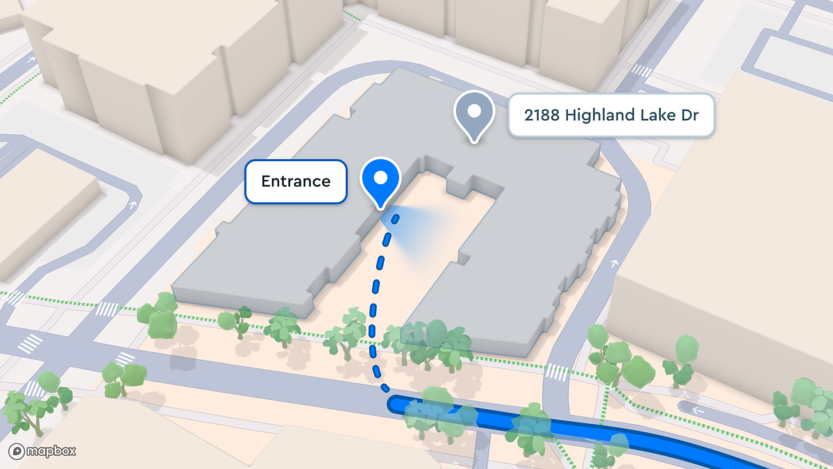
SAN FRANCISCO, CA – February 03, 2026 – The familiar frustration of a delivery driver circling a city block, a ride-hailing car stopping on the wrong side of a massive building, or a package marked 'undeliverable' may soon become a relic of the past. Location platform Mapbox today announced a significant step toward eliminating this last-mile chaos with the public preview of its doorway-level entrance data, a feature designed to guide drivers to within five meters of the correct door, not just the general address.
Covering over 100 million addresses in the United States, the new capability directly confronts what the logistics industry calls the 'final meters' problem—the critical gap between arriving at a street address and finding the specific point of entry. By providing pinpoint coordinates for building entrances, the company aims to transform efficiency for the booming delivery, logistics, and on-demand mobility sectors.
"Doorway-level entrance data helps solve one of the most persistent challenges in delivery and ride-hailing: knowing exactly where to be," said Cherie Wong, SVP of Location Services at Mapbox, in the company's announcement. "Instead of ending navigation with just 'you have arrived,' companies can guide drivers to the right spot—the door that actually matters."
The High Cost of 'Almost There'
The struggle to find the right entrance is more than a minor inconvenience; it's a massive financial drain on the logistics industry. According to research from McKinsey, inefficiencies in the final stage of delivery—such as misplaced drop-offs and the resulting driver dwell time—can account for as much as 19% of total logistics costs. These expenses accumulate through support calls, redelivery attempts, and lost or stolen packages.
Mapbox's own analysis reinforces the severity of this issue, indicating that a staggering 70% of failed deliveries that occur within the last 100 meters of a trip happen in the final 10 meters. With the cost of a single failed delivery averaging over $17, according to industry reports, these small navigational errors translate into millions of dollars in losses and damaged customer trust. In an e-commerce landscape where last-mile services represent over half of total shipping costs, precision is no longer a luxury but an economic necessity.
Early adopters are already seeing tangible returns. Chris Heffernan, CEO of catering delivery service dlivrd, reported significant operational improvements. "Entrance data has saved our drivers time. They spend less time searching and more time setting up," Heffernan stated. "Delivery times are down 7%, support questions are resolved 25% faster—and many never reach us at all."
Beyond the Pin: How the Technology Works
For decades, digital maps have guided users to a single coordinate point, or 'pin,' typically placed at the geographic center of a property's parcel. This system falters in complex environments like corporate campuses, sprawling apartment complexes, or dense urban blocks with multiple entry points. Mapbox's solution enriches this data by adding a new layer of granularity.
Developers using the Mapbox Geocoding API can now enable a new entrances parameter in their requests. When an address is converted into geographic coordinates, the API returns not just a central point but also the precise latitude and longitude of known building entrances. This allows applications to build turn-by-turn navigation that intelligently routes a driver to the correct side of the street and to a specific stopping point in front of the relevant door.
This precision is the product of a massive data processing engine powered by artificial intelligence. The platform ingests and processes approximately 2.1 billion miles of anonymized telemetry data every week from a network of over 45,000 mobile applications and millions of connected vehicle sensors. Neural networks analyze this vast dataset to identify patterns, validate entrance locations, and continuously refine the map. This is further enhanced by a feedback system that allows users to report issues, which are then processed by AI to improve data quality in a continuous, self-correcting loop.
A New Front in the Mapping Wars
Mapbox's targeted launch of doorway-level data marks a strategic move in the highly competitive geospatial market. While industry giants like Google Maps and HERE Technologies possess immense and highly accurate datasets, Mapbox is differentiating itself by productizing a solution to a specific, high-value problem for developers and logistics firms. By making this feature a simple, accessible parameter within its API, the company is betting on flexibility and developer-friendliness to capture a critical segment of the enterprise market.
This focus on solving granular problems appears to be a core part of its strategy. While competitors offer robust geocoding, Mapbox's explicit public push for 'doorway-level' accuracy at such a large scale—over 100 million U.S. addresses—sets a new public benchmark for last-mile navigation services. For developers building the next generation of delivery or ride-hailing apps, the ability to eliminate a major point of user and driver friction provides a compelling competitive advantage.
Paving the Way for an Autonomous Future
While the immediate benefits target human drivers, the long-term implications of doorway-level data extend deep into the future of mobility. The precision offered by this technology is not just helpful but essential for the deployment of autonomous delivery vehicles, drones, and sidewalk robots. These automated systems cannot 'circle the block' or call a customer for directions; they require machine-readable, hyper-precise instructions to navigate from the street to the stoop.
This new data layer serves as a foundational element for the smart city infrastructure of tomorrow. It can enhance emergency response by guiding first responders to the exact entrance of a multi-unit building, improve accessibility for individuals with mobility challenges, and streamline countless other urban services.
This move aligns with Mapbox's broader push into advanced automotive and navigation systems. The company is already providing sophisticated 3D lane-level guidance in partnership with automakers like BMW and has been selected by Toyota to power the navigation in future models. By solving for the final few meters of a journey, Mapbox is building a comprehensive, end-to-end navigational stack that is becoming increasingly critical for both human-driven and autonomous mobility.