Indonesia's Blueprint to Save Its Vanishing Seagrass Meadows
- 40% loss: Indonesia has lost up to 40% of its seagrass beds, with some areas like Java experiencing declines of up to 60%.
- 35x more carbon: Seagrass meadows sequester carbon at a rate 35 times greater per hectare than tropical rainforests.
- 10% of global seagrass: Indonesia is home to at least a tenth of the world's seagrass meadows.
Experts agree that Indonesia's new standardized, multi-stakeholder framework for seagrass conservation is a critical step toward reversing ecosystem decline, improving food security, and enhancing climate resilience through better data coordination and evidence-based policymaking.
Indonesia's Blueprint to Save Its Vanishing Seagrass Meadows
JAKARTA, Indonesia – January 23, 2026 – Beneath the turquoise waters of the world’s largest archipelago, a silent crisis is unfolding. Indonesia’s vast underwater prairies of seagrass—critical ecosystems that support marine biodiversity, secure coastal food supplies, and fight climate change—are disappearing at an alarming rate. In response, the National Research and Innovation Agency of the Republic of Indonesia (BRIN) has unveiled a groundbreaking framework designed to unify the nation's fragmented conservation efforts and turn the tide on this environmental decline.
The new multi-stakeholder approach, detailed in the journal Ocean and Coastal Management, aims to replace a patchwork of inconsistent data with a standardized, nationwide system for monitoring these vital habitats. By fostering collaboration between government agencies, scientists, and local communities, the initiative seeks to build a comprehensive picture of seagrass health, providing the foundation for effective management and protection.
A Crisis in a Crucial Ecosystem
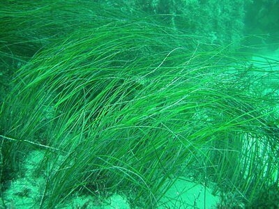
Indonesia is home to at least a tenth of the world's seagrass meadows, which serve as the backbone of its coastal marine environment. These ecosystems are biodiversity hotspots, acting as nurseries for countless fish species that support the food security of millions. Furthermore, they are formidable allies in the climate fight, sequestering carbon from the atmosphere at a rate estimated to be 35 times greater per hectare than tropical rainforests. This stored carbon, known as “blue carbon,” is essential for meeting global climate mitigation targets.
Despite their importance, these underwater gardens are under severe threat. Recent estimates suggest Indonesia may have lost up to 40% of its seagrass beds, with localized declines in heavily populated areas like Java reaching as high as 60%. The culprits are primarily human-induced pressures, including coastal development, land reclamation, pollution from agricultural runoff and waste, destructive fishing practices, and the broader impacts of climate change like rising sea temperatures.
A major obstacle to combating this degradation has been the chaotic state of environmental data. For years, information on seagrass health has been collected by various organizations using different methodologies, resulting in scattered and incompatible datasets. This fragmentation, compounded by inadequate funding and weak coordination, has made it impossible to create the comprehensive national map needed for strategic conservation, hampering initiatives like Indonesia’s “one-map policy” and risking the duplication of effort.
Forging a Unified Front for Data Collection
The framework proposed by BRIN researchers, led by Dr. Nurul Dhewani Mirah Sjafrie, directly confronts these long-standing challenges. The initiative was born from a successful case study that implemented a collaborative approach to data collection, proving that a unified system is not only possible but highly effective.
“Even though field surveys and remote sensing are conventionally used for seagrass data collection, there is an urgent need for standardization,” Dr. Sjafrie explained in the announcement. “We wanted to see if this new framework could help resolve the issues regarding persistent variability.”
The framework is built on four key strategies:
- Establishing a National Partnership: Creating a formal coalition of stakeholders—including government bodies like the Ministry of Marine Affairs and Fisheries, research institutions, NGOs such as WWF Indonesia, and local communities—to share resources and coordinate mapping efforts.
- Standardizing Data Collection Guidelines: Introducing a single, robust methodology for all partners to follow when conducting field surveys and mapping. This ensures that data from different regions and collectors are consistent and comparable.
- Identifying and Engaging Data Collectors: Systematically surveying and identifying individuals and groups across the archipelago who can contribute to the data collection effort, tapping into a wide network of potential participants.
- Building Capacity Through Training: Conducting workshops to train collectors in the standardized methods, including advanced techniques for estimating the carbon storage capacity of seagrass meadows.
This collaborative model has already demonstrated its ability to produce a clean, unified dataset that is highly structured and suitable for nationwide analysis. By improving both data quality and stakeholder coordination, the framework lays the groundwork for evidence-based policymaking.
From Data to Food Security and Climate Resilience
The implications of this initiative extend far beyond scientific databases. By creating a clearer picture of seagrass health, the framework directly supports Indonesia's ability to meet critical United Nations Sustainable Development Goals (SDGs). Healthier seagrass meadows mean more robust fish populations, bolstering local fisheries and contributing to SDG 2 (Zero Hunger). The protection of these ecosystems ensures the stability of livelihoods for countless coastal communities that depend on the sea.
Simultaneously, the framework is a significant step forward for climate action (SDG 13). Improved monitoring of these blue carbon ecosystems allows for more accurate accounting of Indonesia's natural carbon sinks, strengthening the nation's climate mitigation plans. In November 2023, Indonesia launched a climate plan specifically focused on its seagrass meadows, and this new data framework will provide the empirical evidence needed to track progress and guide investment in conservation and restoration.
As Dr. Sjafrie noted, “Studies like this are important for ecosystem conservation. This will not only enable the reduction of global emissions but also support the cause of food safety and biodiversity maintenance.”
A Potential Model for Coastal Nations Worldwide
While the logistical challenge of implementing this framework across an archipelago of over 17,000 islands is immense, its potential is equally vast. Success in Indonesia could position the nation as a global leader in marine conservation, offering a replicable blueprint for other coastal countries struggling with similar issues of data fragmentation and ecosystem decline.
The collaborative, capacity-building approach addresses common barriers like limited funding and technical expertise by pooling resources and empowering local actors. International partners, including the World Bank and Germany's International Climate Initiative (IKI), have already shown support for coastal restoration in the region, and a successful, scalable model for data management could attract further investment.
Ultimately, the journey from fragmented data to a unified national strategy requires sustained political will, long-term financial commitment, and the active participation of all stakeholders. If successful, Indonesia’s effort to map and save its seagrass could create a powerful ripple effect, providing a much-needed model for protecting marine ecosystems in an era of unprecedented environmental change.