- Field Testing: Scheduled for early 2026
- Technologies Combined: Niantic Spatial's Visual Positioning System (VPS) and Vantor's Raptor software
- Precision: Centimeter-level accuracy for navigation without GPS
Experts view this alliance as a critical advancement in resilient navigation, offering a robust alternative to GPS-dependent systems, particularly in contested environments.
GPS-Free Navigation: Niantic & Vantor Forge Air-to-Ground Alliance
SAN FRANCISCO & WESTMINSTER, Colo. – December 16, 2025 – In a move poised to redefine autonomous navigation, geospatial AI pioneer Niantic Spatial and spatial intelligence leader Vantor have announced a partnership to create a unified positioning solution that operates independently of GPS. The collaboration aims to solve one of the most critical vulnerabilities in modern technology: the reliance on satellite signals for navigation, which are increasingly susceptible to jamming, spoofing, and interference.
The joint system, scheduled for field testing in early 2026, will integrate ground-based and aerial technologies to allow autonomous drones, ground vehicles, and even personnel using AR glasses to coordinate and navigate with precision in environments where GPS is denied or unreliable. This alliance marks a significant step toward resilient operations for defense, intelligence, and commercial sectors facing an increasingly complex and contested world.
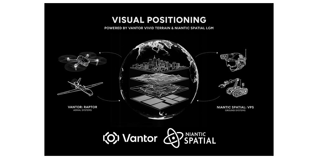
A Unified Front Against GPS Failure
The core of the partnership lies in fusing two powerful, yet distinct, localization technologies to create a single, shared operating picture. Niantic Spatial brings its ground-based Visual Positioning System (VPS), a technology born from its deep experience in augmented reality and large-scale world mapping. VPS uses computer vision to match what a device's camera sees in real-time against a pre-existing, high-fidelity 3D map of the environment, allowing it to determine its position and orientation with centimeter-level accuracy.
This system is powered by Niantic Spatial's Large Geospatial Model (LGM), an advanced AI trained on billions of real-world images and scans. The LGM allows machines to perceive and understand physical spaces, creating a foundational layer for robots and AR wearables to situate themselves and interact with their surroundings intelligently.
Complementing this on-the-ground capability is Vantor's aerial-focused Raptor visual positioning software. Raptor is designed to give aerial platforms, such as drones, the ability to navigate without GPS by correlating their live sensor feeds with Vantor's proprietary 3D terrain data. This technology is a key component of Vantor's broader platform, Tensorglobe, which aims to create an AI-ready digital replica of Earth by fusing data from satellites, aerial sensors, and ground sources.
By integrating Niantic Spatial's VPS and Vantor's Raptor, the two companies will establish a shared coordinate system. A drone in the sky and a soldier or robot on the ground can reference the same visual map, sharing their locations in real-time without a single ping to or from a satellite. This approach relies on foundational concepts like Visual-Inertial Odometry (VIO) and Simultaneous Localization and Mapping (SLAM), which combine camera data with motion sensor inputs to track movement through an unknown space.
“By combining Niantic Spatial’s expertise in ground-based localization with Vantor’s proven aerial systems and global 3D foundation, we’re building an integrated positioning network that operates anywhere,” said Brian McClendon, Chief Technology Officer at Niantic Spatial. “Our Large Geospatial Model gives these systems the ability to perceive, align, and operate in a shared frame of reference — even when traditional GPS is unavailable.”
Strategic Imperatives in a Contested World
The strategic importance of a robust alternative to GPS cannot be overstated. For military and intelligence agencies, the ability to operate effectively in GPS-denied environments is a decisive advantage. Modern adversaries have developed sophisticated electronic warfare capabilities to jam or spoof satellite signals, potentially paralyzing navigation, coordination, and situational awareness on the battlefield.
The Niantic Spatial-Vantor solution directly addresses this threat. It promises to enable unmanned aerial vehicles (UAVs) to conduct reconnaissance in contested airspace, autonomous ground vehicles to resupply front-line units through jammed corridors, and dismounted soldiers to maintain a clear picture of their surroundings in complex urban or subterranean terrain. Vantor, which rebranded from Maxar Intelligence, already has a strong foothold in the defense sector, with partnerships to integrate its Raptor software into systems for companies like Anduril and Saab.
“The rise of autonomous and mixed reality systems is reshaping our world, but these systems only work if they can maintain precise location intelligence when GPS is down,” noted Peter Wilczynski, Vantor’s Chief Product Officer. “Together, we can connect any air- or ground-based camera feed to a unified view of the operational terrain for continuous operations.”
This technology is considered a 'dual-use' asset, meaning it has significant applications for both military and civilian purposes. As such, its development and distribution will be subject to strict regulatory frameworks like the U.S. Export Administration Regulations (EAR), designed to control the spread of sensitive technologies.
Beyond the Battlefield: Commercial and Industrial Frontiers
While the defense implications are profound, the commercial applications for a reliable GPS-free navigation system are equally transformative. Industries from logistics and manufacturing to urban planning and emergency services stand to benefit.
In logistics, autonomous delivery drones and warehouse robots could navigate complex indoor facilities or dense urban canyons where GPS signals are weak or non-existent. This enhances efficiency and enables true end-to-end automation. For the burgeoning autonomous vehicle market, the technology offers a critical layer of redundancy, improving safety and reliability in tunnels, parking garages, and city centers.
The partnership also builds on Niantic Spatial's recent strategic pivot. After selling its iconic games division, which produced Pokémon GO, the company re-emerged with a sharp focus on providing the deep infrastructure for spatial computing. This collaboration is a clear execution of that new mission: building foundational technology that allows machines to intelligently navigate the physical world.
For Vantor, this alliance is a key step in its evolution from a satellite imagery provider to an end-to-end spatial intelligence firm. By integrating ground-level visual data from Niantic Spatial's ecosystem, Vantor enriches its 'digital replica of Earth,' making it more dynamic, comprehensive, and valuable for a wide range of clients who need to understand and operate within a unified intelligence picture. As both companies push the boundaries of what is possible with spatial AI, their combined efforts may soon make the question of GPS availability irrelevant for a new generation of autonomous systems.