- 5,000 square miles of grounded ice lost in Antarctica
- 442 square kilometers of ice lost annually, equivalent to Greater Los Angeles vanishing every three years
- 26 kilometers of retreat for the Thwaites Glacier (Doomsday Glacier) since 1996
Experts agree that the rapid and sustained retreat of key Antarctic glaciers, particularly in West Antarctica, poses a significant threat to global sea levels, necessitating urgent action in coastal planning and climate modeling.
Antarctica's Alarming Retreat: 5,000 Sq. Miles of Ice Lost
HELSINKI, FINLAND – March 03, 2026 – The Earth's vast southern continent is shrinking at an alarming rate. A landmark 30-year study led by researchers at the University of California, Irvine has revealed that nearly a quarter of Antarctica's coastal glaciers are in retreat, resulting in the loss of almost 5,000 square miles of grounded ice—an area equivalent to ten cities the size of Greater Los Angeles.
The research, published in the Proceedings of the National Academy of Sciences, provides one of the most comprehensive and detailed assessments of Antarctic ice loss to date. It leverages an unprecedented combination of data from international government satellites and, crucially, a new generation of commercial radar satellites that can pierce through polar darkness and persistent cloud cover, offering a near-constant watch over the world's most remote and dynamic ice sheets.
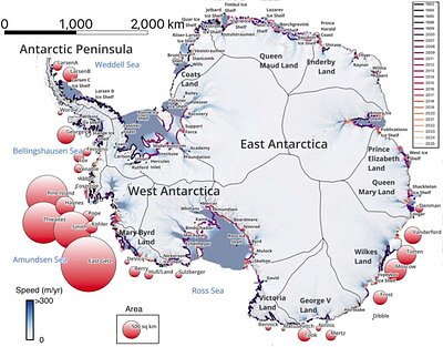
The Unblinking Eye on a Melting Continent
For three decades, scientists have pieced together a picture of Antarctica's health from space. This latest study synthesizes that history, showing that while 77 percent of the continent's coastline has remained relatively stable, the losses in key areas are staggering and concentrated. The study pinpoints the boundary where ice resting on bedrock meets the ocean and begins to float—the “grounding line.” The position of this line is a direct and critical indicator of ice sheet stability.
Worst-hit are the glaciers flowing into the Amundsen and Bellingshausen Seas in West Antarctica, a region long identified by glaciologists as a significant concern for future sea level rise. The data shows a dramatic pullback, with the Smith Glacier retreating 42 kilometers, the Pine Island Glacier 33 kilometers, and the notorious Thwaites Glacier—often called the “Doomsday Glacier”—pulling back 26 kilometers since 1996. Portions of Wilkes Land in East Antarctica are also showing accelerated retreat, challenging previous assumptions about the relative stability of the eastern ice sheet.
This continuous retreat has shed 12,820 square kilometers of grounded ice, with the continent losing ice at an average rate of 442 square kilometers per year. To put that in perspective, it is like watching an area the size of Greater Los Angeles vanish from the ice sheet every three years.
A New Era of Earth Observation
A significant breakthrough enabling this research comes not just from government space agencies but from the private sector. The study was augmented with data from ICEYE, a Finnish company that operates the world's largest constellation of Synthetic Aperture Radar (SAR) satellites. This technology represents a paradigm shift in Earth observation.
Unlike traditional optical satellites that require clear skies and daylight, SAR satellites act as their own flashbulb, sending down radar pulses and measuring the echoes. This allows them to create detailed images of the Earth's surface at any time of day and in any weather. For a place like Antarctica, shrouded in darkness for half the year and frequently covered by clouds, this capability is invaluable.
Furthermore, the frequency of observation has been revolutionized. While legacy satellite missions might revisit a specific location every week or two, commercial constellations like ICEYE's can provide daily revisits. This temporal resolution is critical for understanding the dynamic behavior of grounding lines.
“The grounding line is a direct indicator of ice sheet stability, so if we can't map it accurately, we can't model the ice sheet realistically,” said Michael Wollersheim, Director of InSAR Analytics at ICEYE. “That boundary moves with the tides on timescales of hours to days. Mapping it requires repeat-pass SAR interferometry, which detects the subtle vertical motion as ice lifts off its bed. In fast-moving sectors, the surface changes quickly enough that waiting too long between observations means losing the ability to measure that motion. Short temporal revisit reduces that risk and helps ensure the retreat we report reflects the true pace of change.”
From Polar Ice to Coastal Planning
The implications of these findings extend far beyond the frozen continent, reaching every coastline on the planet. The stability of the Antarctic ice sheet is the single largest uncertainty in projections of future sea level rise. Accurate, long-term observational data like that provided in the UC Irvine study is essential for validating and improving the climate models that governments and planners rely on.
By confirming the rapid and sustained retreat in vulnerable sectors, the research provides a stark warning. The observed changes must be reproducible by any credible ice sheet model, effectively raising the bar for future sea level rise projections. The more accurate the data feeding these models, the more reliable their outputs become for coastal communities preparing for the future.
This enhanced clarity allows urban planners and policymakers to better anticipate the scale and pace of rising seas, informing critical decisions about coastal resilience. Adaptation strategies range from “hard protection” like seawalls and dikes to “soft protection” involving the restoration of natural barriers like mangroves and wetlands. In some cases, it may necessitate difficult conversations about managed retreat from the most vulnerable low-lying areas. The scientific certainty provided by this new wave of satellite data makes such planning not just possible, but imperative.
A Landmark Public-Private Partnership
This research also marks a significant milestone for a new model of scientific discovery. The data from ICEYE and Airbus U.S. was supplied in part through NASA's Commercial Satellite Data Acquisition (CSDA) program. This initiative was designed to evaluate and integrate data from commercial sources to augment NASA's own Earth science missions.
The Antarctic study is being hailed as the program's first major polar research success involving commercial SAR providers. It demonstrates how public-private partnerships can accelerate science and provide insights that would be difficult for either sector to achieve alone.
“30 years ago, monitoring Antarctica's ice meant waiting months between satellite passes and hoping for clear skies,” said Eric Jensen, CEO of ICEYE US. “Today, commercial SAR constellations revisit critical areas daily, in any weather, at any time of day. This study demonstrates the value of commercial radar for understanding our planet, and governments, researchers, and defense planners should expect to rely on it far more in the years ahead.”
The international collaboration, funded by NASA, involved a team of scientists from UC Irvine, NASA's Jet Propulsion Laboratory, and universities in France and Washington, working alongside industry experts from ICEYE. This fusion of academic rigor and commercial innovation provides a powerful new toolkit in the global effort to monitor and respond to climate change, transforming our ability to see and understand our rapidly changing world.
Topics & Related
AI & Machine Learning
Cloud & Infrastructure
Climate Risk
Decarbonization
Net Zero
Generative AI
Machine Learning
GDP
Interest Rates
ChatGPT
Related Company Pulse