- Uranium price: Surpassed $100 per pound in early 2026
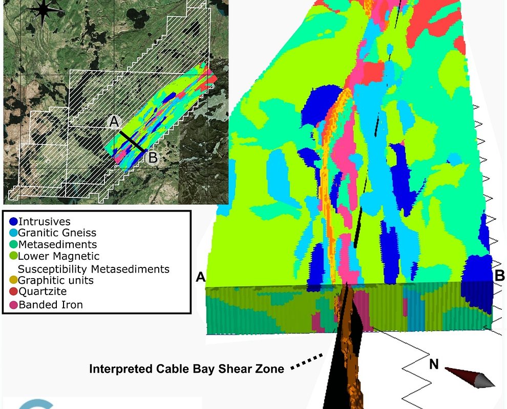
- Drill target area: 15-kilometer stretch along the Cable Bay Shear Zone
- Data integration: 3D model combining 10 years of historical geophysical surveys
Experts would likely conclude that Greenridge's AI-driven approach significantly enhances the precision and efficiency of uranium exploration, potentially reducing costs and increasing the likelihood of discovery in the Athabasca Basin.
Greenridge Deploys AI to Pinpoint Uranium in High-Stakes Hunt
VANCOUVER, BC – April 08, 2026 – In the heart of Canada's prolific Athabasca Basin, a high-tech treasure hunt is underway. Greenridge Exploration Inc. announced today it has completed a sophisticated 3D modelling program at its Carpenter Lake Uranium Project, leveraging artificial intelligence and multi-physics analysis to breathe new life into historical data. The move comes as global uranium prices continue a strong rally, surpassing $100 per pound earlier this year, fueled by a renaissance in nuclear energy and surging electricity demand from the world's data centers.
By creating a detailed digital twin of the subsurface geology, Greenridge has identified a suite of high-priority drill targets along a 15-kilometer stretch of a major structural corridor. The initiative represents a strategic pivot in mineral exploration, demonstrating how advanced technology can unlock significant value from existing assets and sharpen the focus of future drilling campaigns in one of the world's most competitive uranium districts.
The Digital Drill Bit: How AI is Reshaping Exploration
Greenridge's program, executed in collaboration with specialists Convolutions Geoscience Corp. and Computational Geosciences Inc. (CGI), marks a departure from traditional exploration methodologies. Instead of immediately launching costly new geophysical surveys, the company focused on re-interpreting a decade's worth of historical data using CGI’s proprietary Geophysics-Informed Lithology Interpolation (GILI) platform.
The process involved integrating three distinct historical datasets: a 2014 versatile time-domain electromagnetic (VTEM™) survey, which measures how the ground conducts electricity; a 2015 Falcon® airborne gravity survey, which detects subtle variations in rock density; and high-resolution magnetic data, which maps out different rock types based on their magnetic properties. On their own, each dataset provides a piece of the puzzle. When integrated through modern inversion and machine-learning algorithms, they create a comprehensive and cohesive 3D geological model.
This advanced workflow allowed the technical team to peer deep beneath the surface and trace the complex architecture of the Cable Bay Shear Zone (CBSZ), a major fault system known to be highly prospective for hosting uranium mineralization. The GILI model effectively distinguishes between different rock units, crucially highlighting the graphitic pelite horizons—carbon-rich rocks that are highly conductive and often associated with major uranium deposits in the Athabasca Basin. The model also pinpoints areas of low density, which can signify zones of hydrothermal alteration, a key ingredient in the formation of uranium ore.
“Combining the third-party expertise of the Convolutions and CGI teams has enabled the production of a 3D model of the Carpenter Lake geology, which is an example of our Company’s adoption of advanced exploration technology,” stated Russell Starr, CEO of Greenridge. “The Cable Bay Shear Zone is a complex and highly-prospective structure for hosting uranium mineralization, and the joint inversions and resulting GILI model will bolster our future drill targets across more than 15 kilometres of strike length on the Project.”
A High-Stakes Game in the Athabasca Basin
Greenridge’s technological investment is exceptionally timely. The global uranium market is experiencing a structural bull run not seen in over a decade. A confluence of factors—including the drive for decarbonization, renewed focus on energy security following geopolitical instability, and a surprising new demand driver from power-hungry AI infrastructure—has pushed uranium demand to new heights. With years of underinvestment creating a looming supply deficit, prices have responded, and exploration companies are racing to make the next major discovery.
The Athabasca Basin in northern Saskatchewan is ground zero for this race. Revered as the “Saudi Arabia of uranium,” the region hosts the world's highest-grade uranium deposits, making any discovery there potentially transformative. However, these deposits are often buried deep beneath sandstone cover and associated with complex geological structures, making them difficult and expensive to find. Companies like Greenridge, which holds one of Canada's largest uranium property portfolios, are turning to innovation to gain a competitive edge.
By leveraging AI and advanced modelling, the company can de-risk its exploration program in a highly effective manner. This data-driven approach allows for more precise drill targeting, increasing the probability of a successful discovery while potentially reducing the number of costly drill holes required. It represents a shift towards smarter, more efficient exploration that maximizes the value of every dollar spent—a critical advantage in the capital-intensive mining industry.
From Data to Discovery: Pinpointing High-Priority Targets
The ultimate success of the program lies in its tangible results: a clear roadmap for future drilling. The integrated 3D model has illuminated several high-priority target areas where key geological ingredients for a uranium deposit converge. These targets are characterized by the coincidence of steeply-dipping conductive panels (the graphitic pelites), spatially associated density-low anomalies (potential alteration), and structural complexities like breaks and flexures within the shear zone that could act as traps for mineralization.
Crucially, the company reports that many of these newly defined targets remain untested or were only partially tested by historical drilling that may not have been optimally located. The GILI model provides the precise geological context needed to position future drill holes with a much higher degree of confidence. This refined understanding of the structural architecture along the Cable Bay Shear Zone has materially improved the project's discovery potential without breaking new ground.
With a portfolio of promising targets now clearly defined, Greenridge is positioned to embark on its next phase of exploration at Carpenter Lake. The program serves as a powerful case study for the modern mineral explorer, proving that the next major discovery might not come from new surveys, but from looking at old data through a powerful new technological lens.
Topics & Related
Cryptocurrency & Digital Assets
AI & Machine Learning
Decarbonization
Machine Learning
Artificial Intelligence
Revenue
Related Company Pulse