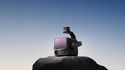
DJI Targets Pro Geospatial Market with Long-Range Zenmuse L3 LiDAR System
DJI’s new Zenmuse L3 LiDAR system isn’t just about capturing data; it’s a strategic play to democratize high-accuracy mapping and surveying for a wider range of industries – and disrupt the existing landscape.
DJI Targets Pro Geospatial Market with Long-Range Zenmuse L3 LiDAR System
By Angela Gray – November 04, 2025
DJI, traditionally known for its consumer and prosumer drones, is making a significant push into the high-end geospatial data market with the launch of the Zenmuse L3 LiDAR system. While aerial LiDAR isn’t new, DJI’s offering promises to lower barriers to entry, potentially reshaping how industries from surveying and construction to environmental monitoring collect and utilize crucial data. This isn’t simply a product launch; it's a strategic play to democratize high-accuracy mapping and surveying for a wider range of users – and disrupt the existing landscape.
Bridging the Accuracy Gap
For years, high-accuracy LiDAR data acquisition has been dominated by specialized, and often expensive, systems. The Zenmuse L3 boasts a range of up to 950 meters with a reported ranging repeatability of 5mm at 150 meters – figures that place it competitively within the professional sphere. What sets it apart, however, isn’t just the raw performance, but how DJI has integrated it into its existing ecosystem.
“The biggest challenge in LiDAR isn’t always the sensor itself, but the workflow,” explains one industry analyst who preferred to remain anonymous. “Traditionally, integrating LiDAR data into usable maps and models required significant expertise and expensive software. DJI’s approach, leveraging Pilot 2, Terra, and FlightHub 2, aims to streamline that process.”
The integrated software suite promises to simplify data acquisition, processing, and analysis, potentially reducing the need for highly specialized personnel and complex workflows. This accessibility is a key differentiator, aiming to bring high-accuracy data within reach of smaller firms and organizations that previously couldn’t afford it.
A Competitive Landscape
DJI enters a market currently populated by established players like Velodyne, Hesai, and RIEGL. These companies have traditionally focused on specialized LiDAR systems for automotive, industrial, and high-end surveying applications. While those systems boast impressive performance, they often come with a hefty price tag and require significant technical expertise to operate.
“DJI is clearly targeting a different segment,” says another source familiar with the LiDAR market. “They’re not trying to compete directly with RIEGL’s high-end airborne systems. Instead, they’re aiming for a sweet spot – a balance between accuracy, affordability, and ease of use.”
The company’s existing drone platform and established user base provide a significant advantage. By offering a fully integrated solution – from the sensor to the software – DJI can create a seamless workflow for its customers, reducing integration challenges and maximizing efficiency.
Beyond Mapping: Expanding Applications
The potential applications for the Zenmuse L3 extend far beyond traditional mapping and surveying. Industries like construction can use LiDAR data to create detailed 3D models of job sites, track progress, and identify potential hazards. Environmental monitoring agencies can utilize LiDAR to assess forest health, map floodplains, and monitor coastal erosion. Infrastructure inspectors can employ LiDAR to detect structural defects and ensure the safety of critical assets.
“The ability to quickly and accurately capture 3D data is becoming increasingly important across a wide range of industries,” explains a construction project manager who is evaluating the Zenmuse L3. “We’re looking for solutions that can help us improve efficiency, reduce costs, and enhance safety, and LiDAR is a key component of that.”
Emergency response teams can also leverage LiDAR data to assess damage after natural disasters, create evacuation plans, and coordinate relief efforts. The ability to rapidly collect and analyze data in these situations can be critical for saving lives and minimizing the impact of emergencies.
Democratization and Disruption: The Long-Term Impact
DJI’s entry into the professional LiDAR market is more than just a product launch; it's a strategic move that has the potential to reshape the industry. By lowering the barriers to entry, DJI is democratizing access to high-accuracy data, enabling a wider range of organizations to benefit from this powerful technology.
However, this democratization may also lead to disruption. Established players in the LiDAR market will need to adapt to the changing landscape, either by lowering their prices, improving their ease of use, or focusing on niche applications.
“The market is going to become much more competitive,” predicts an industry analyst. “DJI is forcing everyone to re-evaluate their strategies and find ways to differentiate themselves.”
The ultimate success of the Zenmuse L3 will depend on its ability to deliver on its promise of affordability, ease of use, and accuracy. However, one thing is clear: DJI’s entry into the professional LiDAR market is a significant development that will have a lasting impact on the industry and the way we collect and utilize geospatial data. As the technology matures and applications expand, we can expect to see even more innovative uses for LiDAR emerge, transforming the way we understand and interact with the world around us.
