- 95% of Earth's landmass covered by Vantor's 3D spatial foundation with 3-meter accuracy
- 15 times per day revisit capability of Vantor's WorldView satellites
- 16 centimeters resolution of ICEYE's SAR satellite imagery
Experts view Project Orbion as a groundbreaking advancement in geospatial intelligence, merging AI, satellite data, and 3D modeling to create a real-time, mission-critical digital twin of Earth for defense, disaster response, and autonomous systems training.
AI & Satellites Forge a Living Digital Twin of Earth
SOUTH SAN FRANCISCO, CA – December 01, 2025 – In a move that signals a paradigm shift in geospatial intelligence, simulation leader Aechelon Technology has announced a pivotal integration that brings its vision of an AI-enabled “Digital Twin of the Earth” closer to reality. The company has successfully fused the all-weather, 24/7 radar vision of ICEYE’s satellite constellation with the hyper-accurate 3D global maps from Vantor, creating a dynamic, mission-ready synthetic environment.
This collaboration, showcased under Aechelon's Project Orbion, is more than a technical milestone; it represents the convergence of previously siloed technologies to create a single, continuously updated, and interactive picture of our planet. By transforming space-based synthetic aperture radar (SAR) data into high-fidelity 3D visualizations, Aechelon is enabling operators to see and interact with a virtual world that mirrors the real one in near real-time, regardless of clouds, smoke, or darkness. The proof-of-concept, demonstrated at the I/ITSEC 2025 conference in Orlando, Florida, offers a compelling glimpse into the future of high-stakes decision-making.
A Symphony of Satellites and Software
The power of Project Orbion lies in a carefully orchestrated partnership, where each company provides a critical and complementary piece of the puzzle. It's a collaboration that leverages decades of specialized expertise to achieve what no single entity could alone.
At the foundation is Vantor, the spatial intelligence giant formerly known as Maxar. Vantor provides the project's structural backbone: a 3D spatial foundation covering over 95% of Earth's landmass with an accuracy of within three meters. This is not a static map but a living globe, constantly refreshed by Vantor's own WorldView satellite constellation, which can revisit a single location up to 15 times a day. This highly accurate and continuously updated 3D terrain serves as the canvas upon which the dynamic world is painted.
Providing the all-weather paint is ICEYE, a leader in SAR satellite technology. Owning the world's largest SAR constellation, ICEYE delivers persistent monitoring capabilities that are immune to weather conditions and time of day. Its satellites can detect millimeter-level changes on the ground and capture imagery at resolutions as fine as 16 centimeters. For Project Orbion, this means a constant stream of intelligence about new objects, environmental changes, and ground activity, filling the gaps where traditional optical satellites are blind.
Aechelon Technology acts as the master integrator and AI architect. The company’s SkyBeam™ AI exploitation system ingests the foundational data from Vantor and the dynamic SAR detections from ICEYE. Its sophisticated algorithms then get to work, visually fusing the datasets. As Nacho Sanz-Pastor, CEO of Aechelon, noted, the partnership is built on a long history of collaboration. "Aechelon and Vantor have sustained a decades-long partnership... This marks the first integration of Vantor's software-enabled spatial intelligence capabilities with Project Orbion, expanding the roster of industry leaders we've brought together to advance next-generation geospatial intelligence."
Forging a 'Living' Synthetic Reality
The term “Digital Twin of the Earth” is gaining currency, with major initiatives from the European Space Agency and tech giants like NVIDIA focused on modeling global systems, primarily for climate science. However, Aechelon’s Project Orbion is carving out a distinct niche focused on operational intelligence and what it calls “Synthetic Reality.”
Instead of modeling long-term climate trends, Project Orbion is designed to provide a continuously updated, sensor-fused 3D environment for immediate, mission-critical use. The system’s AI doesn't just overlay radar blips on a map; it interprets them. Aechelon’s algorithms extract detailed 3D vegetation, process Vantor's building footprints into 3D models, and correlate ICEYE’s SAR detections to place dynamic 3D models of objects—such as aircraft or vehicles—precisely within the synthetic world.
The system’s intelligence extends to environmental modeling. Using machine learning, it can simulate real-time snow accumulation synchronized with an ICEYE satellite pass, ensuring the virtual terrain’s elevation and appearance match the actual conditions on the ground at that moment. This creates a physics-accurate environment where shadows fall correctly for the time of day and environmental factors are realistically represented, which is critical for both human training and AI validation.
This focus on creating a high-fidelity, interactive training ground is a key differentiator. The goal is to provide ground-truth data to train advanced AI models for autonomous systems, allowing them to run thousands of virtual missions in a realistic and dynamic world, thereby refining their algorithms and decision-making capabilities without real-world risk.
From Tactical Rehearsal to Disaster Response
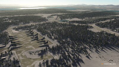
The immediate applications for this technology are profound, particularly in the defense and intelligence sectors. For military planners, Project Orbion offers an unprecedented tool for mission rehearsal. As demonstrated by Aechelon, the system can take actual SAR detections of Russian aircraft, for example, and instantly position their 3D models on a realistic, explorable map of the airfield, complete with accurate buildings, vegetation, and even snow cover. This allows pilots and mission commanders to virtually fly through a target area as it exists now, not as it existed weeks ago when the last clear satellite photo was taken.
Beyond mission planning, this capability is crucial for developing the next generation of autonomous systems, which will need to navigate and operate in complex, GPS-denied environments. By training on a synthetic world built from real, multi-sensor data, these systems can learn to navigate more robustly and effectively.
Yet, the impact of Project Orbion extends far beyond the battlefield. The same all-weather capabilities that are vital for military intelligence are equally transformative for disaster response. After a hurricane, when cloud cover obscures the coastline, SAR can penetrate the weather to assess flood levels and infrastructure damage. Following a wildfire, it can see through smoke to map the burn scar and identify threatened structures. Project Orbion can fuse this data into an immediate 3D damage assessment, providing first responders and emergency managers with the critical situational awareness needed to deploy resources effectively and save lives.
This dual-use potential is at the heart of the platform’s long-term vision. By creating a single, authoritative, and dynamic geospatial ecosystem, Aechelon and its partners are building a foundational technology that can enhance security, improve emergency management, and accelerate the safe deployment of autonomous systems across industries. The live demonstration at I/ITSEC is not just a product showcase; it is a declaration that the line between the real and virtual worlds is becoming ever more seamless, creating a new reality for how we understand and interact with our planet.